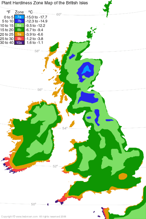
The plant hardiness zone map of the British Isles is the most detailed ever to be created for this region, and is the product of many months work studying the average winter climate statistics for the periods 1961 to 2000 recorded by the Irish and UK Met Offices.
The USA first undertook climatic studies to provide a guide map for plant hardiness of the North American continent. These were undertaken by two independent groups: The Arnold Arboretum of Harvard University in Cambridge, Massachusetts, and the United States Department of Agriculture (USDA) in Washington, D.C. See the USDA map.
When we took it upon ourselves to create the Plant Hardiness Zone Map of the British Isles we replicated the same zones, based on the same equivalent temperature scale as the USA to form a basic standardisation. However, we have changed the colour coding for the 7 split zones occurring in the British Isles to colours which are more meaningful to the average user.
Both our map and the USDA maps are inadequate due to factors such as the frequency and duration of cold outbreaks. The main problem is the fact that the British Isles lies so far north of the equator, where both winter and winter nights are long. No other place on the planet, which shares similar winter temperatures is situated so far from the equator, and therefore our problems are quite unique. The noticeable differences are to be seen in our zones 10a & 9b. Whereas, plants from other country's zones 10a & 9b can whithstand short, colder outbreaks than us and survive, in the British Isles they must endure a winter which is several months long with low light levels and wet weather. Consequently, there are very few plants, labelled as zone 9 or 10 that can be grown here.
It is important to understand that average minimum air temperatures (protected from wind & direct sun) are used in defining these zones. Ambient temperatures will be lowered by local frost pockets and by wind-chill. Although, plants do not suffer from the effects of wind-chill like we do, they can get dehydrated and suffer from windburn in cold easterly winds. Therefore, you must read these zones as the maximum potential temperature for an area once windbreaks have been put in place. For example - If you see from the map that you are in a potential zone 9a then you can over winter plants outdoors, which are suitable for zones 8b, 8a, 7b etc. You will only be able to over winter plants suitable for zone 9a once protection has been put in place and a favourable microclimate created.
Essential reading: Predicting Cold Hardiness in Palms Trebrown Blog.
We had plans for an updated Plant Hardiness Zone Map of the British Isles, and many months work had already gone into this by 2011. The general trend had been a period of increased warming over the decade since we first published the map. However, the British Isles were then hit by two successively cold winters and a third not quite so cold but nevertheless colder than we had been used to. The results of these cold spells has been to bring the pattern of the map back similar to what it was. There are only slight pattern changes from the original map, and for this reason we have decided to save work and retain the original map without an update, as this is the best match for the British Isles without any temporary warming patterns which may be misleading.